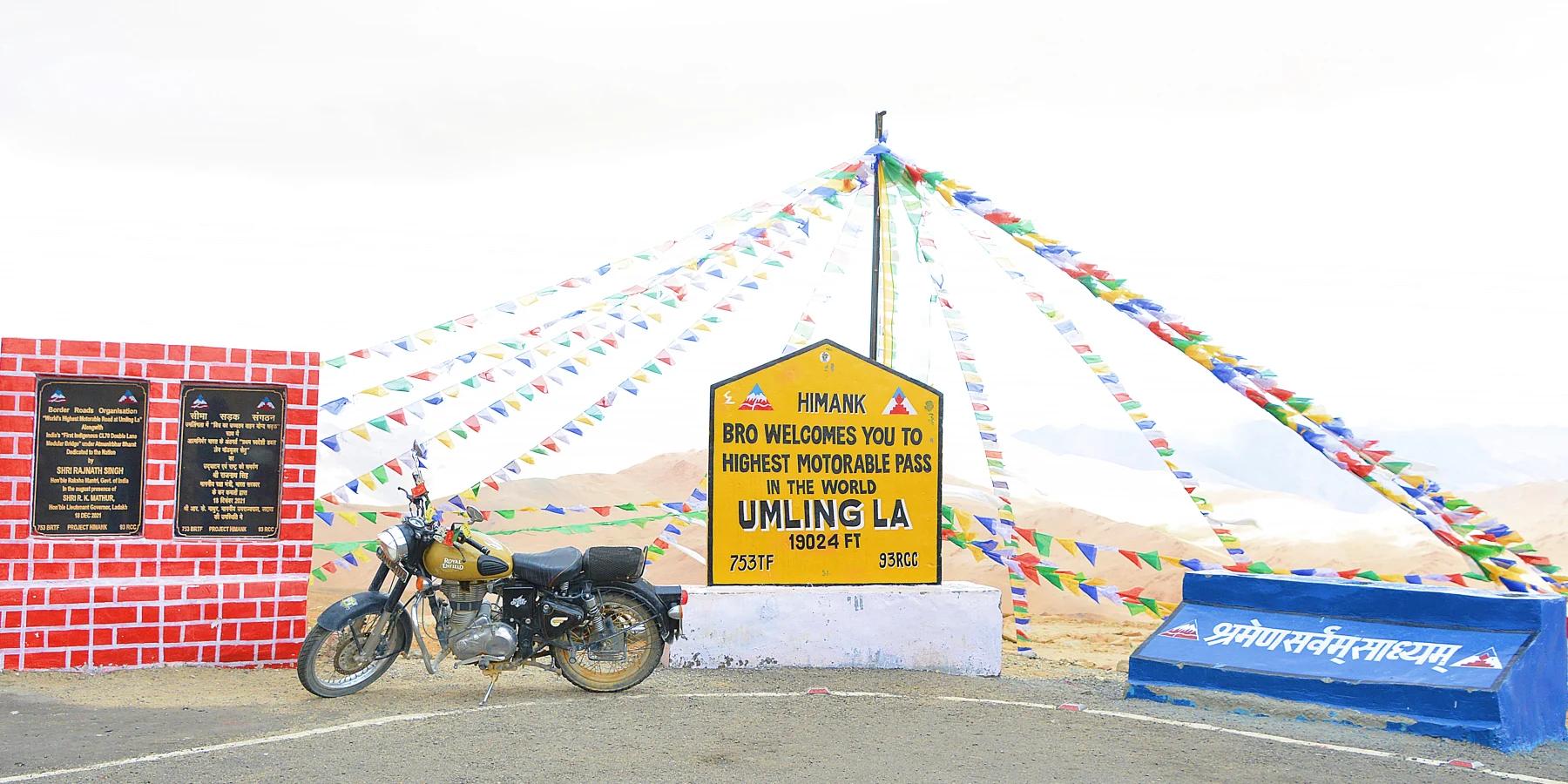
The highest paved road supported by a published independent record is at Umling La in Ladakh, India. Guinness World Records gives an exact elevation of 5,798.251 metres and credits India's Border Roads Organisation, Project Himank and 753 BRTF. Its record date is 9 November 2021, and the formal title is “highest altitude road”.
That answer now needs a qualification. In October 2025, the same road builder announced a new motorable road over Mig La at a claimed 5,913 metres. Indian government material says it surpasses Umling La, but does not describe the new route as paved and does not show a replacement Guinness measurement. As of 22 November 2026, the public Guinness page still names Umling La. A highest motorable road claim and a certified highest hard-surface road are therefore not yet interchangeable.
Five surveyors established the certified height
BRO initially announced Umling La at roughly 5,883 metres in August 2021. The figure on the later certificate is 5,798.251 metres. India's Ministry of Defence says Guinness used five different surveyors during a four-month verification process, explaining why the certified number deserves priority over the early signboard and publicity figure.
The 52-kilometre tarmac road runs from Chisumle to Demchok across the pass. It displaced a road approaching Bolivia's Uturuncu volcano, quoted by the Indian government at about 5,777 metres. The margin may appear modest, but the pass is far beyond the altitude at which rapid ascent can cause serious illness.
This road is also infrastructure, not simply a record attraction. It connects remote settlements and serves a strategic border region close to the Line of Actual Control between India and China. A road can be engineered for vehicles while civilian access remains subject to permits, checkpoints, weather or security decisions.
What the newer Mig La claim establishes
India's public broadcaster Akashvani reported on 4 October 2025 that Project Himank had constructed a road at Mig La at a claimed 5,913 metres. The Likaru–Mig La–Fukche alignment provides a third axis to Fukche village near the border. A January 2026 Press Information Bureau document also calls it the world's highest motorable road and says it exceeds BRO's earlier Umling La record.
Neither official item examined for this article describes the Mig La surface as tarmac or blacktop. Those words were used explicitly for Umling La in 2021. Nor do the newer sources provide a Guinness elevation to the nearest millimetre or link to an updated record entry. This does not disprove the Mig La road; it defines the boundary of the available evidence.
Guinness notes that records change and are not always published immediately. A future certification could alter the hierarchy. Until then, Umling La holds the current published “highest altitude road” record, while Mig La carries the higher motorable-road claim made by BRO and repeated by the Indian government.
Paving does not make 5,798 metres routine
The Ministry of Defence reported winter temperatures down to -40 °C and oxygen levels about 50% below normal during the Umling La project. Those are official statements rather than Carboratory measurements, but they convey why a smooth surface should not be confused with an ordinary mountain drive.
Ladakh Tourism requires visitors arriving in Leh to take at least 48 hours of complete rest for acclimatisation before travelling to higher areas. Its advisory flags the risk of high-altitude pulmonary oedema above 3,500 metres and warns that medical infrastructure is limited in remote Hanle and Changthang. Umling La stands more than 2,200 metres above that risk threshold.
Thin air can reduce output from a naturally aspirated combustion engine. Turbocharging can compensate for part of the density loss, but it does not remove the effects of cold, long distances, climbing load or limited recovery options. On the descent, brake management and tyre condition matter more than the number printed on the summit board.
Electric vehicles avoid combustion air-supply losses, but altitude does not solve their practical constraints. Cabin heating, low battery temperature, repeated climbing and the distance to charging all require planning. Regeneration can help on the descent, yet it can also be limited when a battery is cold or near full. No official source reviewed here establishes a guaranteed charging network on the pass route.
Tourist access is a separate question
The record itself grants no right of entry. Umling La lies in a sensitive border area where permits, checkpoint rules, seasonal closures and photography restrictions can change. A tour operator's itinerary is not a substitute for confirmation from Ladakh Tourism and the competent local authorities.
A responsible plan starts with acclimatisation and current access information, followed by weather, road status, fuel range, water, communications and a retreat option. Passengers must be able to descend if altitude symptoms appear, even when the vehicle is performing normally. Limited medical support makes schedule flexibility a safety requirement rather than a convenience.
The most accurate answer in November 2026 is consequently narrower than the headline superlative. Umling La is the Guinness-listed highest altitude road and has a confirmed paved 52-kilometre alignment at 5,798.251 metres. Mig La is higher according to BRO's motorable-road claim, but the public official evidence does not yet establish the same paving and independent-certification conditions.